Thank you for supporting this site ❤️
Make a donation
Make a donation
Gear up for your next adventure:
As an Amazon Associate, this site earns from qualifying purchases at no extra cost to you.
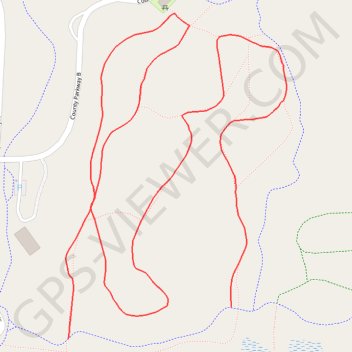
Trails Bunker Hill Park
- Distance: 1.5 mi
- Elevation gain: 26 ft
- Maximum elevation: 919 ft
- Elevation loss: 23 ft
- Minimum elevation: 902 ft
- Moving time: 30 m 14 s
- Moving speed: 3.0 mph
- Maximum speed: 3.9 mph
- Total time: 30 m 14 s
- Global speed: 3.0 mph
Interactive trail map
Thank you for supporting this site ❤️
Make a donation
Make a donation
Gear up for your next adventure:
As an Amazon Associate, this site earns from qualifying purchases at no extra cost to you.
Trail profile
- Distance: 1.5 mi
- Elevation gain: 26 ft
- Maximum elevation: 919 ft
- Elevation loss: 23 ft
- Minimum elevation: 902 ft
- Moving time: 30 m 14 s
- Moving speed: 3.0 mph
- Maximum speed: 3.9 mph
- Total time: 30 m 14 s
- Global speed: 3.0 mph
Thank you for supporting this site ❤️
Make a donation
Make a donation
Gear up for your next adventure:
As an Amazon Associate, this site earns from qualifying purchases at no extra cost to you.
About this trail
Name: Trails Bunker Hill Park trail, distance, elevation, map, profile, GPS track
Coordinates: 45.20317 -93.27979 45.20799 -93.27516
Topography: Anoka County topographic map, elevation, terrain
Thank you for supporting this site ❤️
Make a donation
Make a donation
Gear up for your next adventure:
As an Amazon Associate, this site earns from qualifying purchases at no extra cost to you.