仙姑南坑 鴉山上坑
Hong Kong Hike
- Distance: 8.0 mi
- Elevation gain: 2,812 ft
- Maximum elevation: 2,014 ft
- Elevation loss: 2,759 ft
- Minimum elevation: 13 ft
- Moving time: 2 h 56 m
- Moving speed: 2.7 mph
- Maximum speed: 12.4 mph
- Total time: 4 h 46 m
- Global speed: 1.7 mph
Interactive trail map
Trail profile
- Distance: 8.0 mi
- Elevation gain: 2,812 ft
- Maximum elevation: 2,014 ft
- Elevation loss: 2,759 ft
- Minimum elevation: 13 ft
- Moving time: 2 h 56 m
- Moving speed: 2.7 mph
- Maximum speed: 12.4 mph
- Total time: 4 h 46 m
- Global speed: 1.7 mph
About this trail
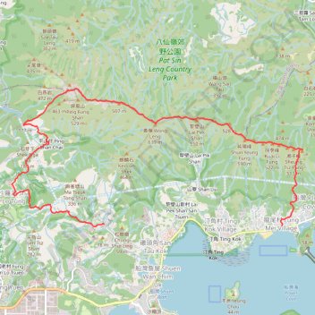
Name: 仙姑南坑 鴉山上坑 trail, distance, elevation, map, profile, GPS track
Coordinates: 22.47243 114.18230 22.49508 114.23405
Other hiking, mountain biking, running and outdoor activity trails
Click on a trail to view its statistics, map and profile.
Wilson Trail Full Route
China > Hong Kong > Hong Kong Island
Distance: 50.5 mi • Elevation gain: 14,534 ft • Maximum elevation: 2,011 ft
鬼叫坑
China > Hong Kong > North District > Wu Kau Tang > San Uk Ha
Distance: 11.3 mi • Elevation gain: 1,824 ft • Maximum elevation: 830 ft
犁橫石澗下右源
China > Hong Kong > North District > Wu Kau Tang > Sam Tam Lo
Distance: 7.7 mi • Elevation gain: 2,198 ft • Maximum elevation: 2,011 ft