Thank you for supporting this site ❤️
Make a donation
Make a donation
Gear up for your next adventure:
As an Amazon Associate, this site earns from qualifying purchases at no extra cost to you.
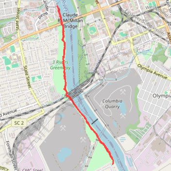
Cayce Riverwalk hike
- Distance: 3.9 mi
- Elevation gain: 141 ft
- Maximum elevation: 157 ft
- Elevation loss: 138 ft
- Minimum elevation: 125 ft
- Moving time: 1 h 35 m
- Moving speed: 2.4 mph
- Maximum speed: 5.3 mph
- Total time: 1 h 37 m
- Global speed: 2.4 mph
Interactive trail map
Thank you for supporting this site ❤️
Make a donation
Make a donation
Gear up for your next adventure:
As an Amazon Associate, this site earns from qualifying purchases at no extra cost to you.
Trail profile
- Distance: 3.9 mi
- Elevation gain: 141 ft
- Maximum elevation: 157 ft
- Elevation loss: 138 ft
- Minimum elevation: 125 ft
- Moving time: 1 h 35 m
- Moving speed: 2.4 mph
- Maximum speed: 5.3 mph
- Total time: 1 h 37 m
- Global speed: 2.4 mph
Thank you for supporting this site ❤️
Make a donation
Make a donation
Gear up for your next adventure:
As an Amazon Associate, this site earns from qualifying purchases at no extra cost to you.
About this trail
Name: Cayce Riverwalk hike trail, distance, elevation, map, profile, GPS track
Coordinates: 33.96606 -81.04902 33.99007 -81.03880
Topography: Lexington County topographic map, elevation, terrain
Thank you for supporting this site ❤️
Make a donation
Make a donation
Gear up for your next adventure:
As an Amazon Associate, this site earns from qualifying purchases at no extra cost to you.