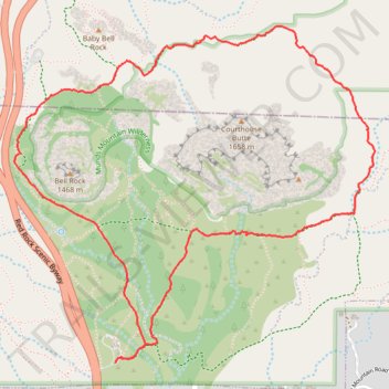
Bell Rock and Courthouse Butte Loop via Bell Rock Pathway and Big Park Loop
The Bell Rock and Courthouse Butte Loop in Coconino National Forest offers hikers a scenic journey around two of the area's most iconic red rock formations, the distinctive Bell Rock, a dome-shaped butte, and the imposing Courthouse Butte. Along the well-marked trail, you'll encounter diverse desert flora, including large agave plants and cacti, and enjoy panoramic views of landmarks like Cathedral Rock and Gibraltar Rock. This relatively flat and accessible hike is suitable for all ages and skill levels, making it a popular choice for those seeking to experience Sedona's natural beauty. #Hiking #Nature #Loop #Rock #Forest
- Distance: 4.3 mi
- Elevation gain: 413 ft
- Maximum elevation: 4,478 ft
- Elevation loss: 413 ft
- Minimum elevation: 4,173 ft
- Moving time: 1 h 16 m
- Moving speed: 3.3 mph
- Maximum speed: 6.4 mph
- Total time: 1 h 17 m
- Global speed: 3.3 mph
Interactive trail map
Trail profile
- Distance: 4.3 mi
- Elevation gain: 413 ft
- Maximum elevation: 4,478 ft
- Elevation loss: 413 ft
- Minimum elevation: 4,173 ft
- Moving time: 1 h 16 m
- Moving speed: 3.3 mph
- Maximum speed: 6.4 mph
- Total time: 1 h 17 m
- Global speed: 3.3 mph
About this trail
Name: Bell Rock and Courthouse Butte Loop via Bell Rock Pathway and Big Park Loop trail, distance, elevation, map, profile, GPS track
Start: Bell Rock Vista, FR 9879, Yavapai County, Arizona, 86351, United States (34.79118 -111.76193)
End: Bell Rock Vista, FR 9879, Yavapai County, Arizona, 86351, United States (34.79123 -111.76192)
Coordinates: 34.79118 -111.76782 34.80731 -111.74680
Topography: Yavapai County topographic map, elevation, terrain
Other hiking, mountain biking, running and outdoor activity trails
Click on a trail to view its statistics, map and profile.
Bell Rock Pathway to Upper Bell Rock Trail in Coconino National Forest
United States > Arizona > Yavapai County
The Bell Rock Pathway to Upper Bell Rock Trail in Coconino National Forest offers hikers a captivating journey through Sedona's iconic red rock formations. Along the route, you'll encounter panoramic vistas of Bell Rock and Courthouse Butte, with their distinctive red sandstone cliffs and spires. The trail…
Distance: 2.6 mi • Elevation gain: 384 ft • Maximum elevation: 4,547 ft
Bell Rock Loop Trail in Munds Mountain Wilderness
United States > Arizona > Coconino County
The Bell Rock Loop Trail offers an unforgettable experience with its panoramic views of Sedona’s iconic red rock formations, including Bell Rock and Courthouse Butte. The trail is well-suited for all levels, offering a relatively short and easy hike, though the area is exposed to the sun. For those looking…
Distance: 1.9 mi • Elevation gain: 243 ft • Maximum elevation: 4,449 ft