Make a donation
Gear up for your next adventure:
As an Amazon Associate, this site earns from qualifying purchases at no extra cost to you.
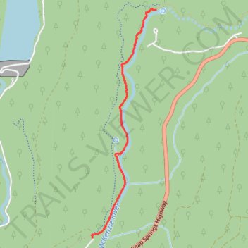
Tamolitch Blue Pool via McKenzie River Trail in Willamette National Forest
The hike to Tamolitch Blue Pool offers a captivating journey through diverse landscapes along the McKenzie River. Starting in an old-growth Douglas fir forest, the trail crosses a stream on a wooden bridge and leads to expansive lava fields. The trail culminates at the mesmerizing blue pool, set against the surrounding cliffs, where the McKenzie River emerges from beneath a lava flow, creating a serene and picturesque spot. #Hiking #River #Forest #Nature #Lake
- Distance: 3.7 mi
- Elevation gain: 344 ft
- Maximum elevation: 2,438 ft
- Elevation loss: 348 ft
- Minimum elevation: 2,244 ft
- Moving time: 1 h 16 m
- Moving speed: 2.9 mph
- Maximum speed: 6.4 mph
- Total time: 1 h 17 m
- Global speed: 2.9 mph
Interactive trail map
Make a donation
Gear up for your next adventure:
As an Amazon Associate, this site earns from qualifying purchases at no extra cost to you.
Trail profile
- Distance: 3.7 mi
- Elevation gain: 344 ft
- Maximum elevation: 2,438 ft
- Elevation loss: 348 ft
- Minimum elevation: 2,244 ft
- Moving time: 1 h 16 m
- Moving speed: 2.9 mph
- Maximum speed: 6.4 mph
- Total time: 1 h 17 m
- Global speed: 2.9 mph
Make a donation
Gear up for your next adventure:
As an Amazon Associate, this site earns from qualifying purchases at no extra cost to you.
About this trail
Name: Tamolitch Blue Pool via McKenzie River Trail in Willamette National Forest trail, distance, elevation, map, profile, GPS track
Start: Forest Road 2672-655, Linn County, Oregon, United States (44.29036 -122.03566)
Coordinates: 44.29031 -122.03585 44.31233 -122.02718
Topography: Linn County topographic map, elevation, terrain
Make a donation
Gear up for your next adventure:
As an Amazon Associate, this site earns from qualifying purchases at no extra cost to you.
Other hiking, mountain biking, running and outdoor activity trails
Click on a trail to view its statistics, map and profile.
Northern part of the Pacific Crest Trail (PCT)
United States > Oregon > Klamath County
Hike on the Pacific Crest National Scenic Trail from Crater Lake to Canada Border through Oregon and Washington along the Sierra Nevada and Cascade mountain ranges. #Hiking #Mountain #SierraNevada #Cascade #Nature #Forest #Park #PCT
Distance: 744.6 mi • Elevation gain: 145,367 ft • Maximum elevation: 7,569 ft