Thank you for supporting this site ❤️
Make a donation
Make a donation
Gear up for your next adventure:
As an Amazon Associate, this site earns from qualifying purchases at no extra cost to you.
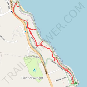
Yaroomba Coolum Foreshore Trail
- Distance: 1.9 mi
- Elevation gain: 328 ft
- Maximum elevation: 108 ft
- Elevation loss: 328 ft
- Minimum elevation: 16 ft
- Moving time: 54 m 14 s
- Moving speed: 2.1 mph
- Maximum speed: 4.0 mph
- Total time: 1 h 48 m
- Global speed: 1.1 mph
Interactive trail map
Thank you for supporting this site ❤️
Make a donation
Make a donation
Gear up for your next adventure:
As an Amazon Associate, this site earns from qualifying purchases at no extra cost to you.
Trail profile
- Distance: 1.9 mi
- Elevation gain: 328 ft
- Maximum elevation: 108 ft
- Elevation loss: 328 ft
- Minimum elevation: 16 ft
- Moving time: 54 m 14 s
- Moving speed: 2.1 mph
- Maximum speed: 4.0 mph
- Total time: 1 h 48 m
- Global speed: 1.1 mph
Thank you for supporting this site ❤️
Make a donation
Make a donation
Gear up for your next adventure:
As an Amazon Associate, this site earns from qualifying purchases at no extra cost to you.
About this trail
Name: Yaroomba Coolum Foreshore Trail trail, distance, elevation, map, profile, GPS track
Coordinates: -26.54674 153.09549 -26.53887 153.10212
Thank you for supporting this site ❤️
Make a donation
Make a donation
Gear up for your next adventure:
As an Amazon Associate, this site earns from qualifying purchases at no extra cost to you.