Thank you for supporting this site ❤️
Make a donation
Make a donation
Gear up for your next adventure:
As an Amazon Associate, this site earns from qualifying purchases at no extra cost to you.
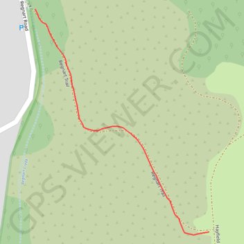
Insta360 GPS Data
- Distance: 0.2 mi
- Elevation gain: 174 ft
- Maximum elevation: 837 ft
- Elevation loss: 0 ft
- Minimum elevation: 663 ft
- Moving time: 4 m 18 s
- Moving speed: 3.1 mph
- Maximum speed: 4.9 mph
- Total time: 4 m 18 s
- Global speed: 3.1 mph
Interactive trail map
Thank you for supporting this site ❤️
Make a donation
Make a donation
Gear up for your next adventure:
As an Amazon Associate, this site earns from qualifying purchases at no extra cost to you.
Trail profile
- Distance: 0.2 mi
- Elevation gain: 174 ft
- Maximum elevation: 837 ft
- Elevation loss: 0 ft
- Minimum elevation: 663 ft
- Moving time: 4 m 18 s
- Moving speed: 3.1 mph
- Maximum speed: 4.9 mph
- Total time: 4 m 18 s
- Global speed: 3.1 mph
Thank you for supporting this site ❤️
Make a donation
Make a donation
Gear up for your next adventure:
As an Amazon Associate, this site earns from qualifying purchases at no extra cost to you.
About this trail
Name: Insta360 GPS Data trail, distance, elevation, map, profile, GPS track
Start: Regnart Trail, Cupertino, Santa Clara County, California, United States (37.29301 -122.06231)
End: Regnart Trail, Cupertino, Santa Clara County, California, United States (37.29077 -122.06011)
Coordinates: 37.29074 -122.06231 37.29301 -122.06011
Topography: Cupertino topographic map, elevation, terrain
Thank you for supporting this site ❤️
Make a donation
Make a donation
Gear up for your next adventure:
As an Amazon Associate, this site earns from qualifying purchases at no extra cost to you.