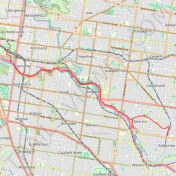
Jolimont Station to Ashburton along Yarra River, Gardiners Creek and Ferndale Trails
- Distance: 9.0 mi
- Elevation gain: 377 ft
- Maximum elevation: 184 ft
- Elevation loss: 285 ft
- Minimum elevation: 13 ft
- Moving time: 1 h 53 s
- Moving speed: 8.8 mph
- Maximum speed: 21.8 mph
- Total time: 1 h 50 m
- Global speed: 4.9 mph
Interactive trail map
Trail profile
- Distance: 9.0 mi
- Elevation gain: 377 ft
- Maximum elevation: 184 ft
- Elevation loss: 285 ft
- Minimum elevation: 13 ft
- Moving time: 1 h 53 s
- Moving speed: 8.8 mph
- Maximum speed: 21.8 mph
- Total time: 1 h 50 m
- Global speed: 4.9 mph
About this trail
Name: Jolimont Station to Ashburton along Yarra River, Gardiners Creek and Ferndale Trails trail, distance, elevation, map, profile, GPS track
Coordinates: -37.86269 144.98295 -37.81681 145.08255
Other hiking, mountain biking, running and outdoor activity trails
Click on a trail to view its statistics, map and profile.
Fawkner Park and Royal Botanic Gardens loop walk
Australia > Victoria > Melbourne
Distance: 7.5 mi • Elevation gain: 449 ft • Maximum elevation: 125 ft
Ashburton to Mernda (cycle)
Australia > Victoria > Melbourne
Distance: 26.2 mi • Elevation gain: 1,286 ft • Maximum elevation: 535 ft
Melbourne Bike Ride
Australia > Victoria > Melbourne
Distance: 28.1 mi • Elevation gain: 892 ft • Maximum elevation: 364 ft
Zeopoxa Cycling
Australia > Victoria > Melbourne
Distance: 7.0 mi • Elevation gain: 312 ft • Maximum elevation: 102 ft