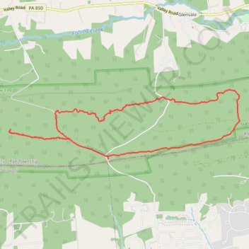
Thank you for supporting this site ❤️
Make a donation
Make a donation
Gear up for your next adventure:
As an Amazon Associate, this site earns from qualifying purchases at no extra cost to you.
PA SGL 170
- Distance: 6.3 mi
- Elevation gain: 653 ft
- Maximum elevation: 1,138 ft
- Elevation loss: 653 ft
- Minimum elevation: 633 ft
- Moving time: 1 h 59 m
- Moving speed: 3.2 mph
- Maximum speed: 7.2 mph
- Total time: 2 h 5 m
- Global speed: 3.0 mph
Interactive trail map
Thank you for supporting this site ❤️
Make a donation
Make a donation
Gear up for your next adventure:
As an Amazon Associate, this site earns from qualifying purchases at no extra cost to you.
Trail profile
- Distance: 6.3 mi
- Elevation gain: 653 ft
- Maximum elevation: 1,138 ft
- Elevation loss: 653 ft
- Minimum elevation: 633 ft
- Moving time: 1 h 59 m
- Moving speed: 3.2 mph
- Maximum speed: 7.2 mph
- Total time: 2 h 5 m
- Global speed: 3.0 mph
Thank you for supporting this site ❤️
Make a donation
Make a donation
Gear up for your next adventure:
As an Amazon Associate, this site earns from qualifying purchases at no extra cost to you.
About this trail
Name: PA SGL 170 trail, distance, elevation, map, profile, GPS track
Coordinates: 40.30509 -77.03317 40.31519 -76.98915
Topography: Rye Township topographic map, elevation, terrain
Thank you for supporting this site ❤️
Make a donation
Make a donation
Gear up for your next adventure:
As an Amazon Associate, this site earns from qualifying purchases at no extra cost to you.