Make a donation
Gear up for your next adventure:
As an Amazon Associate, this site earns from qualifying purchases at no extra cost to you.
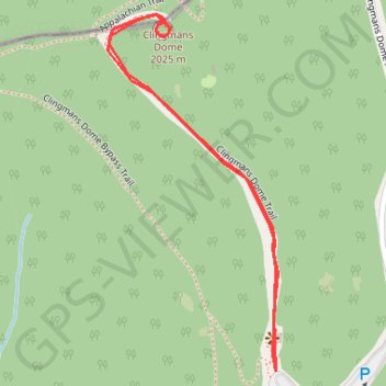
Clingmans Dome
Interactive trail map
Make a donation
Gear up for your next adventure:
As an Amazon Associate, this site earns from qualifying purchases at no extra cost to you.
Trail profile
- Distance: 1.2 mi
- Elevation gain: 338 ft
- Maximum elevation: 6,631 ft
- Elevation loss: 338 ft
- Minimum elevation: 6,293 ft
Make a donation
Gear up for your next adventure:
As an Amazon Associate, this site earns from qualifying purchases at no extra cost to you.
About this trail
Name: Clingmans Dome trail, distance, elevation, map, profile, GPS track
Start: Kuwohi Road Primary Parking, Swain County, North Carolina, United States (35.55689 -83.49610)
End: Kuwohi Road Primary Parking, Swain County, North Carolina, United States (35.55689 -83.49610)
Coordinates: 35.55689 -83.49965 35.56302 -83.49607
Topography: Swain County topographic map, elevation, terrain
Make a donation
Gear up for your next adventure:
As an Amazon Associate, this site earns from qualifying purchases at no extra cost to you.
Other hiking, mountain biking, running and outdoor activity trails
Click on a trail to view its statistics, map and profile.
Kuwohi Trail to Observation Tower in the Great Smoky Mountains National Park
United States > North Carolina > Swain County
The hike to the Kuwohi Observation Tower offers stunning panoramic views from the highest point in the park, previously known as Clingmans Dome. As you ascend the paved, yet steep, trail, you'll be rewarded with vistas of expansive mountain ranges, including Sugarland Mountain and the Elkmont area. On clear…
Distance: 1.3 mi • Elevation gain: 348 ft • Maximum elevation: 6,631 ft
Great Smoky Mountains Appalachian Trail
United States > North Carolina > Clay County
Hike through Great Smoky Mountains along Appalachian Trail via Standing Indian, Ridgepole Mountain, Yellow Bald, Wine Spring Bald, Copper Ridge Bald, Cheoah Bald, Wauchecha Bald, Fontana Dam, Thunderhead Mountain, Clingmans Dome, Mount Kephart and Mount Guyot. #Hiking #Mountain #Nature #Forest #Lake…
Distance: 144.0 mi • Elevation gain: 29,111 ft • Maximum elevation: 6,604 ft