Thank you for supporting this site ❤️
Make a donation
Make a donation
Gear up for your next adventure:
As an Amazon Associate, this site earns from qualifying purchases at no extra cost to you.
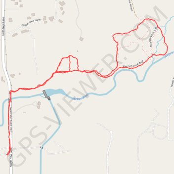
New Lane to Franson Loop
- Distance: 2.5 mi
- Elevation gain: 75 ft
- Maximum elevation: 6,549 ft
- Elevation loss: 72 ft
- Minimum elevation: 6,483 ft
- Moving time: 55 m 35 s
- Moving speed: 2.7 mph
- Maximum speed: 13.6 mph
- Total time: 56 m 22 s
- Global speed: 2.7 mph
Interactive trail map
Thank you for supporting this site ❤️
Make a donation
Make a donation
Gear up for your next adventure:
As an Amazon Associate, this site earns from qualifying purchases at no extra cost to you.
Trail profile
- Distance: 2.5 mi
- Elevation gain: 75 ft
- Maximum elevation: 6,549 ft
- Elevation loss: 72 ft
- Minimum elevation: 6,483 ft
- Moving time: 55 m 35 s
- Moving speed: 2.7 mph
- Maximum speed: 13.6 mph
- Total time: 56 m 22 s
- Global speed: 2.7 mph
Thank you for supporting this site ❤️
Make a donation
Make a donation
Gear up for your next adventure:
As an Amazon Associate, this site earns from qualifying purchases at no extra cost to you.
About this trail
Name: New Lane to Franson Loop trail, distance, elevation, map, profile, GPS track
Start: North New Lane, Oakley, Summit County, Utah, United States (40.71244 -111.28136)
End: North New Lane, Oakley, Summit County, Utah, United States (40.71245 -111.28122)
Coordinates: 40.71239 -111.28136 40.72026 -111.26909
Topography: Summit County topographic map, elevation, terrain
Thank you for supporting this site ❤️
Make a donation
Make a donation
Gear up for your next adventure:
As an Amazon Associate, this site earns from qualifying purchases at no extra cost to you.