Make a donation
Gear up for your next adventure:
As an Amazon Associate, this site earns from qualifying purchases at no extra cost to you.
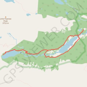
Lake Isabelle and Long Lake Loop
Interactive trail map
Make a donation
Gear up for your next adventure:
As an Amazon Associate, this site earns from qualifying purchases at no extra cost to you.
Trail profile
- Distance: 5.5 mi
- Elevation gain: 728 ft
- Maximum elevation: 10,984 ft
- Elevation loss: 728 ft
- Minimum elevation: 10,515 ft
Make a donation
Gear up for your next adventure:
As an Amazon Associate, this site earns from qualifying purchases at no extra cost to you.
About this trail
Name: Lake Isabelle and Long Lake Loop trail, distance, elevation, map, profile, GPS track
Coordinates: 40.06790 -105.62242 40.07787 -105.58446
Topography: Boulder County topographic map, elevation, terrain
Make a donation
Gear up for your next adventure:
As an Amazon Associate, this site earns from qualifying purchases at no extra cost to you.
Other hiking, mountain biking, running and outdoor activity trails
Click on a trail to view its statistics, map and profile.
Lake Isabelle, Long Lake, and Brainard Lake Loop in Indian Peaks Wilderness
United States > Colorado > Boulder County
The Lake Isabelle, Long Lake, and Brainard Lake Loop in Colorado's Indian Peaks Wilderness offers hikers a journey through diverse landscapes, including wildflower meadows, subalpine forests, and mountain vistas. Along the trail, one can observe Long Lake and Lake Isabelle, both set against a backdrop of…
Distance: 6.3 mi • Elevation gain: 781 ft • Maximum elevation: 10,955 ft
Lone Eagle Peak - Pawnee Pass
United States > Colorado > Grand County
Lake Ganby, Monarch Lake, Crater Lake, Triangle Lake, Pawnee Lake, Lake Isabelle, Long Lake. Rocky Mountains. #Hiking #RockyMountains
Distance: 20.4 mi • Elevation gain: 6,581 ft • Maximum elevation: 12,546 ft