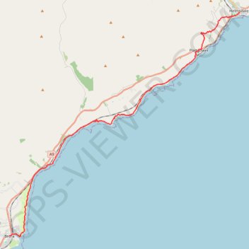
John O'Groats Trail - Brora to Helmsdale
- Distance: 13.3 mi
- Elevation gain: 817 ft
- Maximum elevation: 328 ft
- Elevation loss: 837 ft
- Minimum elevation: 0 ft
- Moving time: 5 h 35 m
- Moving speed: 2.4 mph
- Maximum speed: 4.1 mph
- Total time: 6 h 25 m
- Global speed: 2.1 mph
Interactive trail map
Trail profile
- Distance: 13.3 mi
- Elevation gain: 817 ft
- Maximum elevation: 328 ft
- Elevation loss: 837 ft
- Minimum elevation: 0 ft
- Moving time: 5 h 35 m
- Moving speed: 2.4 mph
- Maximum speed: 4.1 mph
- Total time: 6 h 25 m
- Global speed: 2.1 mph
About this trail
Name: John O'Groats Trail - Brora to Helmsdale trail, distance, elevation, map, profile, GPS track
Coordinates: 58.01074 -3.85498 58.11610 -3.65085
Other hiking, mountain biking, running and outdoor activity trails
Click on a trail to view its statistics, map and profile.
John O'Groats Trail - Helmsdale to Berriedale
United Kingdom > Scotland > Highland > Helmsdale
Distance: 10.9 mi • Elevation gain: 2,661 ft • Maximum elevation: 699 ft
Dunbeath - Dornoch
United Kingdom > Scotland > Highland > Houstry
Distance: 45.3 mi • Elevation gain: 2,946 ft • Maximum elevation: 755 ft