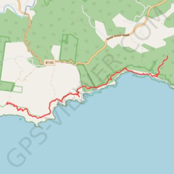
Milanesia Gate - Moonlight Head
Interactive trail map
Trail profile
- Distance: 7.3 mi
- Elevation gain: 1,821 ft
- Maximum elevation: 604 ft
- Elevation loss: 1,890 ft
- Minimum elevation: 0 ft
About this trail
Name: Milanesia Gate - Moonlight Head trail, distance, elevation, map, profile, GPS track
Start: 285, Melanesia Track, Yuulong, Shire of Colac Otway, Victoria, 3237, Australia (-38.74412 143.32297)
End: Great Ocean Walk, Wattle Hill, Shire of Corangamite, Victoria, 3237, Australia (-38.76234 143.24216)
Coordinates: -38.76877 143.24153 -38.74412 143.32303
Other hiking, mountain biking, running and outdoor activity trails
Click on a trail to view its statistics, map and profile.
Great Ocean Walk - Milanesia Track - The Gables
Great Otway National Park. #Hiking #GreatOtway
Distance: 9.9 mi • Elevation gain: 2,467 ft • Maximum elevation: 545 ft