Thank you for supporting this site ❤️
Make a donation
Make a donation
Gear up for your next adventure:
As an Amazon Associate, this site earns from qualifying purchases at no extra cost to you.
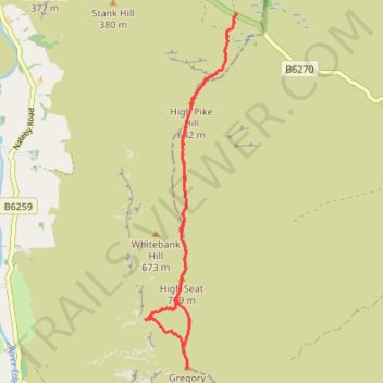
High Pike Hill, High Seat and Gregory Chapel hike in Yorkshire Dales National Park
- Distance: 6.1 mi
- Elevation gain: 1,122 ft
- Maximum elevation: 2,329 ft
- Elevation loss: 1,122 ft
- Minimum elevation: 1,634 ft
- Moving time: 3 h 46 m
- Moving speed: 1.6 mph
- Maximum speed: 2.8 mph
- Total time: 5 h 43 m
- Global speed: 1.1 mph
Interactive trail map
Thank you for supporting this site ❤️
Make a donation
Make a donation
Gear up for your next adventure:
As an Amazon Associate, this site earns from qualifying purchases at no extra cost to you.
Trail profile
- Distance: 6.1 mi
- Elevation gain: 1,122 ft
- Maximum elevation: 2,329 ft
- Elevation loss: 1,122 ft
- Minimum elevation: 1,634 ft
- Moving time: 3 h 46 m
- Moving speed: 1.6 mph
- Maximum speed: 2.8 mph
- Total time: 5 h 43 m
- Global speed: 1.1 mph
Thank you for supporting this site ❤️
Make a donation
Make a donation
Gear up for your next adventure:
As an Amazon Associate, this site earns from qualifying purchases at no extra cost to you.
About this trail
Name: High Pike Hill, High Seat and Gregory Chapel hike in Yorkshire Dales National Park trail, distance, elevation, map, profile, GPS track
Coordinates: 54.39697 -2.31284 54.43352 -2.29670
Thank you for supporting this site ❤️
Make a donation
Make a donation
Gear up for your next adventure:
As an Amazon Associate, this site earns from qualifying purchases at no extra cost to you.