Make a donation
Gear up for your next adventure:
As an Amazon Associate, this site earns from qualifying purchases at no extra cost to you.
Mount Umunhum
Hike to Mount Umunhum via Mount Umunhum Trail and Guadalupe Creek Overlook in the Sierra Azul Open Space Preserve. #Hiking #Mountain #Nature #Forest #Overlook
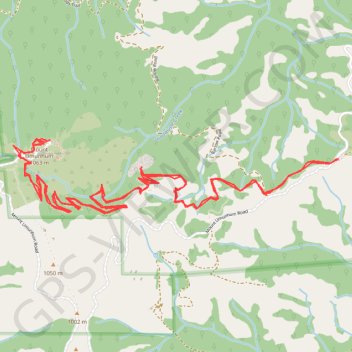
- Distance: 7.5 mi
- Elevation gain: 2,077 ft
- Maximum elevation: 3,432 ft
- Elevation loss: 2,080 ft
- Minimum elevation: 2,254 ft
- Moving time: 2 h 39 m
- Moving speed: 2.8 mph
- Maximum speed: 5.5 mph
- Total time: 2 h 57 m
- Global speed: 2.5 mph
Interactive trail map
Make a donation
Gear up for your next adventure:
As an Amazon Associate, this site earns from qualifying purchases at no extra cost to you.
Trail profile
- Distance: 7.5 mi
- Elevation gain: 2,077 ft
- Maximum elevation: 3,432 ft
- Elevation loss: 2,080 ft
- Minimum elevation: 2,254 ft
- Moving time: 2 h 39 m
- Moving speed: 2.8 mph
- Maximum speed: 5.5 mph
- Total time: 2 h 57 m
- Global speed: 2.5 mph
Make a donation
Gear up for your next adventure:
As an Amazon Associate, this site earns from qualifying purchases at no extra cost to you.
About this trail
Name: Mount Umunhum trail, distance, elevation, map, profile, GPS track
End: Bald Mountain Trail, Santa Clara County, California, United States (37.15950 -121.87564)
Coordinates: 37.15613 -121.90088 37.16075 -121.87564
Topography: Santa Clara County topographic map, elevation, terrain
Make a donation
Gear up for your next adventure:
As an Amazon Associate, this site earns from qualifying purchases at no extra cost to you.
Other hiking, mountain biking, running and outdoor activity trails
Click on a trail to view its statistics, map and profile.
Mount Umunhum Trail via Guadalupe Creek Overlook in Sierra Azul Open Space Preserve
United States > California > Santa Clara County
The Mount Umunhum Trail via the Guadalupe Creek Overlook offers hikers a varied and rewarding experience, showcasing a range of ecosystems from oak woodlands to chaparral scrub. Along the route, visitors are treated to expansive views of the Santa Clara Valley and surrounding mountain ranges, with notable…
Distance: 7.9 mi • Elevation gain: 1,962 ft • Maximum elevation: 3,438 ft