Thank you for supporting this site ❤️
Make a donation
Make a donation
Gear up for your next adventure:
As an Amazon Associate, this site earns from qualifying purchases at no extra cost to you.
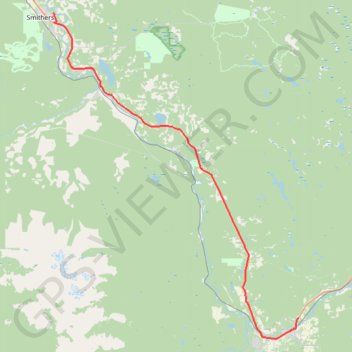
Smithers - Houston
Interactive trail map
Thank you for supporting this site ❤️
Make a donation
Make a donation
Gear up for your next adventure:
As an Amazon Associate, this site earns from qualifying purchases at no extra cost to you.
Trail profile
- Distance: 40.8 mi
- Elevation gain: 2,106 ft
- Maximum elevation: 2,762 ft
- Elevation loss: 1,598 ft
- Minimum elevation: 1,545 ft
Thank you for supporting this site ❤️
Make a donation
Make a donation
Gear up for your next adventure:
As an Amazon Associate, this site earns from qualifying purchases at no extra cost to you.
About this trail
Name: Smithers - Houston trail, distance, elevation, map, profile, GPS track
Coordinates: 54.38898 -127.14819 54.78373 -126.63610
Thank you for supporting this site ❤️
Make a donation
Make a donation
Gear up for your next adventure:
As an Amazon Associate, this site earns from qualifying purchases at no extra cost to you.
Other hiking, mountain biking, running and outdoor activity trails
Click on a trail to view its statistics, map and profile.
Steelhead Park
Canada > British Columbia > Regional District of Bulkley-Nechako > Houston
Distance: 0.4 mi • Elevation gain: 7 ft • Maximum elevation: 1,955 ft