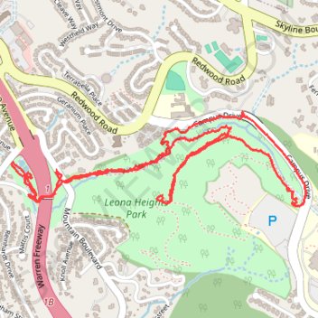
Oakland - McCrea Park and Leona Heights Park Loop
Loop hike in McCrea Park and Leona Heights Park via Oakland Casting Club Pools, Oakleaf Street, York Trail, Campus Drive, McDonell Trail and Old Survivor Redwood Tree. #Hiking #Loop #Park #Nature #Forest
- Distance: 3.3 mi
- Elevation gain: 745 ft
- Maximum elevation: 856 ft
- Elevation loss: 748 ft
- Minimum elevation: 308 ft
- Moving time: 1 h 35 m
- Moving speed: 2.1 mph
- Maximum speed: 5.0 mph
- Total time: 1 h 50 m
- Global speed: 1.8 mph
Interactive trail map
Trail profile
- Distance: 3.3 mi
- Elevation gain: 745 ft
- Maximum elevation: 856 ft
- Elevation loss: 748 ft
- Minimum elevation: 308 ft
- Moving time: 1 h 35 m
- Moving speed: 2.1 mph
- Maximum speed: 5.0 mph
- Total time: 1 h 50 m
- Global speed: 1.8 mph
About this trail
Name: Oakland - McCrea Park and Leona Heights Park Loop trail, distance, elevation, map, profile, GPS track
Coordinates: 37.79124 -122.18267 37.79500 -122.16776
Topography: Oakland topographic map, elevation, terrain
Other hiking, mountain biking, running and outdoor activity trails
Click on a trail to view its statistics, map and profile.
Leona Heights short fire trail hike
United States > California > Alameda County > Oakland
Oakland Walking
Distance: 1.9 mi • Elevation gain: 423 ft • Maximum elevation: 512 ft