Thank you for supporting this site ❤️
Make a donation
Make a donation
Gear up for your next adventure:
As an Amazon Associate, this site earns from qualifying purchases at no extra cost to you.
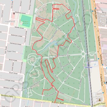
Paths and highways in Fawkner Memorial Park
- Distance: 2.6 mi
- Elevation gain: 69 ft
- Maximum elevation: 256 ft
- Elevation loss: 62 ft
- Minimum elevation: 230 ft
- Moving time: 23 m 34 s
- Moving speed: 6.5 mph
- Maximum speed: 13.0 mph
- Total time: 23 m 34 s
- Global speed: 6.5 mph
Interactive trail map
Thank you for supporting this site ❤️
Make a donation
Make a donation
Gear up for your next adventure:
As an Amazon Associate, this site earns from qualifying purchases at no extra cost to you.
Trail profile
- Distance: 2.6 mi
- Elevation gain: 69 ft
- Maximum elevation: 256 ft
- Elevation loss: 62 ft
- Minimum elevation: 230 ft
- Moving time: 23 m 34 s
- Moving speed: 6.5 mph
- Maximum speed: 13.0 mph
- Total time: 23 m 34 s
- Global speed: 6.5 mph
Thank you for supporting this site ❤️
Make a donation
Make a donation
Gear up for your next adventure:
As an Amazon Associate, this site earns from qualifying purchases at no extra cost to you.
About this trail
Name: Paths and highways in Fawkner Memorial Park trail, distance, elevation, map, profile, GPS track
Coordinates: -37.71862 144.95321 -37.70839 144.95875
Thank you for supporting this site ❤️
Make a donation
Make a donation
Gear up for your next adventure:
As an Amazon Associate, this site earns from qualifying purchases at no extra cost to you.
Other hiking, mountain biking, running and outdoor activity trails
Click on a trail to view its statistics, map and profile.
Melbourne Bike Ride
Australia > Victoria > Melbourne
Distance: 28.1 mi • Elevation gain: 892 ft • Maximum elevation: 364 ft