Thank you for supporting this site ❤️
Make a donation
Make a donation
Gear up for your next adventure:
As an Amazon Associate, this site earns from qualifying purchases at no extra cost to you.
Panorama Ridge
Garibaldi Provincial Park. #Hiking #PanoramaRidge #Garibaldi
- Distance: 8.4 mi
- Elevation gain: 5,466 ft
- Maximum elevation: 6,939 ft
- Elevation loss: 423 ft
- Minimum elevation: 1,893 ft
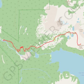
Interactive trail map
Thank you for supporting this site ❤️
Make a donation
Make a donation
Gear up for your next adventure:
As an Amazon Associate, this site earns from qualifying purchases at no extra cost to you.
Trail profile
- Distance: 8.4 mi
- Elevation gain: 5,466 ft
- Maximum elevation: 6,939 ft
- Elevation loss: 423 ft
- Minimum elevation: 1,893 ft
Thank you for supporting this site ❤️
Make a donation
Make a donation
Gear up for your next adventure:
As an Amazon Associate, this site earns from qualifying purchases at no extra cost to you.
About this trail
Name: Panorama Ridge trail, distance, elevation, map, profile, GPS track
Coordinates: 49.94703 -123.12039 49.96485 -123.01350
Thank you for supporting this site ❤️
Make a donation
Make a donation
Gear up for your next adventure:
As an Amazon Associate, this site earns from qualifying purchases at no extra cost to you.
Other hiking, mountain biking, running and outdoor activity trails
Click on a trail to view its statistics, map and profile.