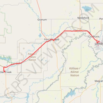
Pincher Creek - Lethbridge
#Bike #PincherCreek #Lethbridge
- Distance: 63.1 mi
- Elevation gain: 748 ft
- Maximum elevation: 3,760 ft
- Elevation loss: 1,722 ft
- Minimum elevation: 2,707 ft
Interactive trail map
Trail profile
- Distance: 63.1 mi
- Elevation gain: 748 ft
- Maximum elevation: 3,760 ft
- Elevation loss: 1,722 ft
- Minimum elevation: 2,707 ft
About this trail
Name: Pincher Creek - Lethbridge trail, distance, elevation, map, profile, GPS track
Start: Cowboy Trail, Pincher Creek, Alberta, T0K 1W0, Canada (49.49290 -113.93645)
Coordinates: 49.48559 -113.94801 49.78561 -112.86866
Other hiking, mountain biking, running and outdoor activity trails
Click on a trail to view its statistics, map and profile.
Blairmore - Pincher Creek
Canada > Alberta > Crowsnest Pass
#Bike #Blairmore #PincherCreek
Distance: 29.4 mi • Elevation gain: 850 ft • Maximum elevation: 4,278 ft
Lethbridge - Bow Island
Canada > Alberta > Lethbridge County > Lethbridge
Distance: 72.6 mi • Elevation gain: 896 ft • Maximum elevation: 3,031 ft