Make a donation
Gear up for your next adventure:
As an Amazon Associate, this site earns from qualifying purchases at no extra cost to you.
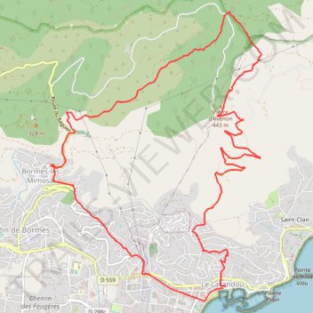
Au-dessus de Bormes-Les-Mimosas _ variante courte_2025-10-16_14-17-03
- Distance: 8.9 mi
- Elevation gain: 1,699 ft
- Maximum elevation: 1,516 ft
- Elevation loss: 1,706 ft
- Minimum elevation: 7 ft
Interactive trail map
Make a donation
Gear up for your next adventure:
As an Amazon Associate, this site earns from qualifying purchases at no extra cost to you.
Trail profile
- Distance: 8.9 mi
- Elevation gain: 1,699 ft
- Maximum elevation: 1,516 ft
- Elevation loss: 1,706 ft
- Minimum elevation: 7 ft
Make a donation
Gear up for your next adventure:
As an Amazon Associate, this site earns from qualifying purchases at no extra cost to you.
About this trail
Name: Au-dessus de Bormes-Les-Mimosas _ variante courte_2025-10-16_14-17-03 trail, distance, elevation, map, profile, GPS track
Coordinates: 43.13636 6.34343 43.16932 6.37627
Make a donation
Gear up for your next adventure:
As an Amazon Associate, this site earns from qualifying purchases at no extra cost to you.
Other hiking, mountain biking, running and outdoor activity trails
Click on a trail to view its statistics, map and profile.
1 LUCENA - MONTPELLIER
Distance: 1,842.0 mi • Elevation gain: 96,785 ft • Maximum elevation: 3,438 ft
PT23DS2 Lörrach → Cadaqués
Germany > Baden-Württemberg > Landkreis Lörrach > Lörrach (Kernstadt)
Distance: 652.9 mi • Elevation gain: 43,077 ft • Maximum elevation: 4,938 ft
AU DESSUS DE BORMES LES MIMOSAS
France > Provence-Alpes-Côte d'Azur > Var > Le Lavandou
Distance: 11.0 mi • Elevation gain: 2,369 ft • Maximum elevation: 1,516 ft