Thank you for supporting this site ❤️
Make a donation
Make a donation
Gear up for your next adventure:
As an Amazon Associate, this site earns from qualifying purchases at no extra cost to you.
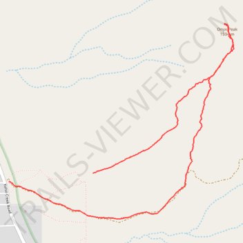
Onyx Peak loop
- Distance: 3.9 mi
- Elevation gain: 2,126 ft
- Maximum elevation: 5,200 ft
- Elevation loss: 2,425 ft
- Minimum elevation: 2,776 ft
- Moving time: 3 h 18 s
- Moving speed: 1.3 mph
- Maximum speed: 4.2 mph
- Total time: 8 h 28 s
- Global speed: 0.5 mph
Interactive trail map
Thank you for supporting this site ❤️
Make a donation
Make a donation
Gear up for your next adventure:
As an Amazon Associate, this site earns from qualifying purchases at no extra cost to you.
Trail profile
- Distance: 3.9 mi
- Elevation gain: 2,126 ft
- Maximum elevation: 5,200 ft
- Elevation loss: 2,425 ft
- Minimum elevation: 2,776 ft
- Moving time: 3 h 18 s
- Moving speed: 1.3 mph
- Maximum speed: 4.2 mph
- Total time: 8 h 28 s
- Global speed: 0.5 mph
Thank you for supporting this site ❤️
Make a donation
Make a donation
Gear up for your next adventure:
As an Amazon Associate, this site earns from qualifying purchases at no extra cost to you.
About this trail
Name: Onyx Peak loop trail, distance, elevation, map, profile, GPS track
Start: Kern County, California, United States (35.64435 -118.24043)
End: 4221, Kelso Creek Road, Weldon, Kern County, California, 93283, United States (35.64362 -118.24912)
Coordinates: 35.64046 -118.24912 35.65694 -118.22579
Topography: Kern County topographic map, elevation, terrain
Thank you for supporting this site ❤️
Make a donation
Make a donation
Gear up for your next adventure:
As an Amazon Associate, this site earns from qualifying purchases at no extra cost to you.