Thank you for supporting this site ❤️
Make a donation
Make a donation
Gear up for your next adventure:
As an Amazon Associate, this site earns from qualifying purchases at no extra cost to you.
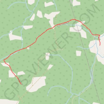
Parlee Brook Amphitheatre
- Distance: 4.1 mi
- Elevation gain: 1,010 ft
- Maximum elevation: 1,014 ft
- Elevation loss: 1,010 ft
- Minimum elevation: 374 ft
Interactive trail map
Thank you for supporting this site ❤️
Make a donation
Make a donation
Gear up for your next adventure:
As an Amazon Associate, this site earns from qualifying purchases at no extra cost to you.
Trail profile
- Distance: 4.1 mi
- Elevation gain: 1,010 ft
- Maximum elevation: 1,014 ft
- Elevation loss: 1,010 ft
- Minimum elevation: 374 ft
Thank you for supporting this site ❤️
Make a donation
Make a donation
Gear up for your next adventure:
As an Amazon Associate, this site earns from qualifying purchases at no extra cost to you.
About this trail
Name: Parlee Brook Amphitheatre trail, distance, elevation, map, profile, GPS track
Coordinates: 45.64235 -65.43344 45.65435 -65.40804
Thank you for supporting this site ❤️
Make a donation
Make a donation
Gear up for your next adventure:
As an Amazon Associate, this site earns from qualifying purchases at no extra cost to you.