Make a donation
Gear up for your next adventure:
As an Amazon Associate, this site earns from qualifying purchases at no extra cost to you.
Mesa Butte
Kananaskis Country Public Land Use Zone. #Hiking #Kananaskis
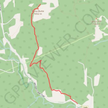
- Distance: 5.0 mi
- Elevation gain: 1,631 ft
- Maximum elevation: 5,531 ft
- Elevation loss: 1,631 ft
- Minimum elevation: 4,498 ft
Interactive trail map
Make a donation
Gear up for your next adventure:
As an Amazon Associate, this site earns from qualifying purchases at no extra cost to you.
Trail profile
- Distance: 5.0 mi
- Elevation gain: 1,631 ft
- Maximum elevation: 5,531 ft
- Elevation loss: 1,631 ft
- Minimum elevation: 4,498 ft
Make a donation
Gear up for your next adventure:
As an Amazon Associate, this site earns from qualifying purchases at no extra cost to you.
About this trail
Name: Mesa Butte trail, distance, elevation, map, profile, GPS track
Start: McLean Creek Trail, Kananaskis Improvement District, Alberta, Canada (50.75637 -114.54618)
End: McLean Creek Trail, Kananaskis Improvement District, Alberta, Canada (50.75637 -114.54618)
Coordinates: 50.75637 -114.56397 50.78005 -114.54618
Make a donation
Gear up for your next adventure:
As an Amazon Associate, this site earns from qualifying purchases at no extra cost to you.
Other hiking, mountain biking, running and outdoor activity trails
Click on a trail to view its statistics, map and profile.
Mesa Butte to Sandy McNabb
Canada > Alberta > Kananaskis Improvement District
Distance: 12.5 mi • Elevation gain: 1,342 ft • Maximum elevation: 5,026 ft