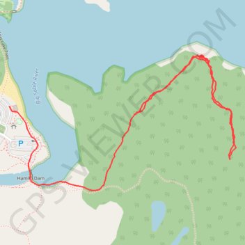
Hike to Inspiration Point
- Distance: 1.7 mi
- Elevation gain: 167 ft
- Maximum elevation: 686 ft
- Elevation loss: 210 ft
- Minimum elevation: 594 ft
- Moving time: 46 m 24 s
- Moving speed: 2.2 mph
- Maximum speed: 10.7 mph
- Total time: 1 h 14 m
- Global speed: 1.4 mph
Interactive trail map
Trail profile
- Distance: 1.7 mi
- Elevation gain: 167 ft
- Maximum elevation: 686 ft
- Elevation loss: 210 ft
- Minimum elevation: 594 ft
- Moving time: 46 m 24 s
- Moving speed: 2.2 mph
- Maximum speed: 10.7 mph
- Total time: 1 h 14 m
- Global speed: 1.4 mph
About this trail
Name: Hike to Inspiration Point trail, distance, elevation, map, profile, GPS track
End: Lost Lake Trail, Hamlin Township, Mason County, Michigan, United States (44.03486 -86.49325)
Coordinates: 44.03209 -86.49325 44.03657 -86.48287
Topography: Mason County topographic map, elevation, terrain
Other hiking, mountain biking, running and outdoor activity trails
Click on a trail to view its statistics, map and profile.