Thank you for supporting this site ❤️
Make a donation
Make a donation
Gear up for your next adventure:
As an Amazon Associate, this site earns from qualifying purchases at no extra cost to you.
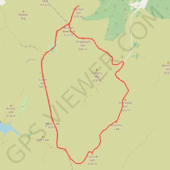
Culter Fell Donalds
Culter, Fell, Donalds
- Distance: 9.8 mi
- Elevation gain: 3,130 ft
- Maximum elevation: 2,438 ft
- Elevation loss: 3,130 ft
- Minimum elevation: 883 ft
- Moving time: 4 h 51 m
- Moving speed: 2.0 mph
- Maximum speed: 5.9 mph
- Total time: 5 h 18 m
- Global speed: 1.9 mph
Interactive trail map
Thank you for supporting this site ❤️
Make a donation
Make a donation
Gear up for your next adventure:
As an Amazon Associate, this site earns from qualifying purchases at no extra cost to you.
Trail profile
- Distance: 9.8 mi
- Elevation gain: 3,130 ft
- Maximum elevation: 2,438 ft
- Elevation loss: 3,130 ft
- Minimum elevation: 883 ft
- Moving time: 4 h 51 m
- Moving speed: 2.0 mph
- Maximum speed: 5.9 mph
- Total time: 5 h 18 m
- Global speed: 1.9 mph
Thank you for supporting this site ❤️
Make a donation
Make a donation
Gear up for your next adventure:
As an Amazon Associate, this site earns from qualifying purchases at no extra cost to you.
About this trail
Name: Culter Fell Donalds trail, distance, elevation, map, profile, GPS track
Start: Scottish Borders, Scotland, ML12 6QL, United Kingdom (55.55075 -3.45841)
End: Scottish Borders, Scotland, ML12 6QL, United Kingdom (55.55076 -3.45833)
Coordinates: 55.51879 -3.50355 55.56794 -3.45522
Thank you for supporting this site ❤️
Make a donation
Make a donation
Gear up for your next adventure:
As an Amazon Associate, this site earns from qualifying purchases at no extra cost to you.