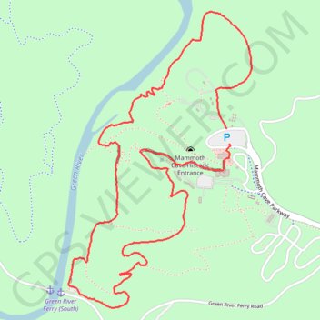
Green River Bluffs Trail, Echo River Springs Trail, Sinkhole Trail and Heritage Trail Loop
This loop in Mammoth Cave National Park offer a diverse range of outdoor experiences, showcasing Kentucky’s unique geological features. Hikers can expect to see sweeping views of the Green River and its surrounding bluffs, sinkholes, and natural springs, while walking through shaded woodlands, past limestone formations, and sometimes even near cave entrances. The trails provide a great way to explore the park's above-ground beauty, with opportunities for wildlife spotting, wildflower sightings, and peaceful riverside walks, all while traversing a mix of terrain from gravel paths to more forested routes. #Hiking #Loop #River #Forest #Nature
- Distance: 4.2 mi
- Elevation gain: 679 ft
- Maximum elevation: 781 ft
- Elevation loss: 689 ft
- Minimum elevation: 449 ft
- Moving time: 1 h 30 m
- Moving speed: 2.8 mph
- Maximum speed: 6.4 mph
- Total time: 1 h 30 m
- Global speed: 2.8 mph
Interactive trail map
Trail profile
- Distance: 4.2 mi
- Elevation gain: 679 ft
- Maximum elevation: 781 ft
- Elevation loss: 689 ft
- Minimum elevation: 449 ft
- Moving time: 1 h 30 m
- Moving speed: 2.8 mph
- Maximum speed: 6.4 mph
- Total time: 1 h 30 m
- Global speed: 2.8 mph
About this trail
Name: Green River Bluffs Trail, Echo River Springs Trail, Sinkhole Trail and Heritage Trail Loop trail, distance, elevation, map, profile, GPS track
Start: Mammoth Cave Parkway, Edmonson County, Kentucky, United States (37.18846 -86.10105)
End: Mammoth Cave Parkway, Edmonson County, Kentucky, United States (37.18764 -86.10083)
Coordinates: 37.17868 -86.11185 37.19484 -86.09933
Topography: Edmonson County topographic map, elevation, terrain