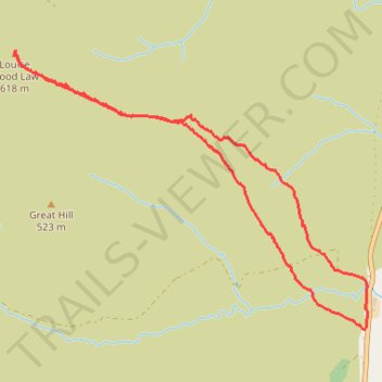
Hillwalk Louise Wood Law
- Distance: 3.4 mi
- Elevation gain: 1,083 ft
- Maximum elevation: 2,011 ft
- Elevation loss: 1,086 ft
- Minimum elevation: 925 ft
- Moving time: 1 h 44 m
- Moving speed: 2.0 mph
- Maximum speed: 4.3 mph
- Total time: 1 h 47 m
- Global speed: 1.9 mph
Interactive trail map
Trail profile
- Distance: 3.4 mi
- Elevation gain: 1,083 ft
- Maximum elevation: 2,011 ft
- Elevation loss: 1,086 ft
- Minimum elevation: 925 ft
- Moving time: 1 h 44 m
- Moving speed: 2.0 mph
- Maximum speed: 4.3 mph
- Total time: 1 h 47 m
- Global speed: 1.9 mph
About this trail
Name: Hillwalk Louise Wood Law trail, distance, elevation, map, profile, GPS track
Start: A702, Watermeetings, South Lanarkshire, Scotland, ML12 6TH, United Kingdom (55.40617 -3.65903)
End: A702, Watermeetings, South Lanarkshire, Scotland, ML12 6TH, United Kingdom (55.40610 -3.65889)
Coordinates: 55.40610 -3.68888 55.41967 -3.65863