Make a donation
Gear up for your next adventure:
As an Amazon Associate, this site earns from qualifying purchases at no extra cost to you.
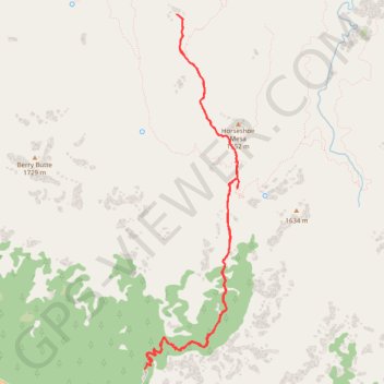
Grandview Trail (Grand Canyon)
Hike along the Grandview Trail from Grandview Point in the Grand Canyon National Park. #Hiking #Canyon #Mountain #Nature #Rock #River #Park
- Distance: 8.6 mi
- Elevation gain: 3,773 ft
- Maximum elevation: 7,395 ft
- Elevation loss: 3,514 ft
- Minimum elevation: 4,780 ft
- Moving time: 4 h 27 m
- Moving speed: 1.9 mph
- Maximum speed: 5.7 mph
- Total time: 5 h 18 m
- Global speed: 1.6 mph
Interactive trail map
Make a donation
Gear up for your next adventure:
As an Amazon Associate, this site earns from qualifying purchases at no extra cost to you.
Trail profile
- Distance: 8.6 mi
- Elevation gain: 3,773 ft
- Maximum elevation: 7,395 ft
- Elevation loss: 3,514 ft
- Minimum elevation: 4,780 ft
- Moving time: 4 h 27 m
- Moving speed: 1.9 mph
- Maximum speed: 5.7 mph
- Total time: 5 h 18 m
- Global speed: 1.6 mph
Make a donation
Gear up for your next adventure:
As an Amazon Associate, this site earns from qualifying purchases at no extra cost to you.
About this trail
Name: Grandview Trail (Grand Canyon) trail, distance, elevation, map, profile, GPS track
Start: Grandview Trail, Coconino County, Arizona, United States (35.99913 -111.98718)
End: Grandview Trail, Coconino County, Arizona, United States (35.99805 -111.98790)
Coordinates: 35.99805 -111.98790 36.03572 -111.97553
Topography: Coconino County topographic map, elevation, terrain
Make a donation
Gear up for your next adventure:
As an Amazon Associate, this site earns from qualifying purchases at no extra cost to you.
Other hiking, mountain biking, running and outdoor activity trails
Click on a trail to view its statistics, map and profile.