Make a donation
Gear up for your next adventure:
As an Amazon Associate, this site earns from qualifying purchases at no extra cost to you.
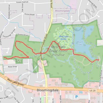
Meacham Grove Forest Preserve
Hike through Meacham Grove Forest Preserve via North Central DuPage Regional Trail and Mapple Lake. #Hiking #Nature #Forest #Lake
- Distance: 1.6 mi
- Elevation gain: 33 ft
- Maximum elevation: 797 ft
- Elevation loss: 102 ft
- Minimum elevation: 719 ft
- Moving time: 20 m 4 s
- Moving speed: 4.7 mph
- Maximum speed: 12.3 mph
- Total time: 20 m 4 s
- Global speed: 4.7 mph
Interactive trail map
Make a donation
Gear up for your next adventure:
As an Amazon Associate, this site earns from qualifying purchases at no extra cost to you.
Trail profile
- Distance: 1.6 mi
- Elevation gain: 33 ft
- Maximum elevation: 797 ft
- Elevation loss: 102 ft
- Minimum elevation: 719 ft
- Moving time: 20 m 4 s
- Moving speed: 4.7 mph
- Maximum speed: 12.3 mph
- Total time: 20 m 4 s
- Global speed: 4.7 mph
Make a donation
Gear up for your next adventure:
As an Amazon Associate, this site earns from qualifying purchases at no extra cost to you.
About this trail
Name: Meacham Grove Forest Preserve trail, distance, elevation, map, profile, GPS track
End: Maple Lake Trail, Bloomingdale, DuPage County, Illinois, 60157, United States (41.96187 -88.07095)
Coordinates: 41.96151 -88.08933 41.96456 -88.07095
Topography: DuPage County topographic map, elevation, terrain
Make a donation
Gear up for your next adventure:
As an Amazon Associate, this site earns from qualifying purchases at no extra cost to you.