Coal Canyon
Hike to the summit of the Coal Canyon Ecological Preserve via the Santa Ana River, the Chino Hills State Park and the Coal Canyon Trail. #Hiking #Nature #Mountain #River #Forest #Canyon #Park
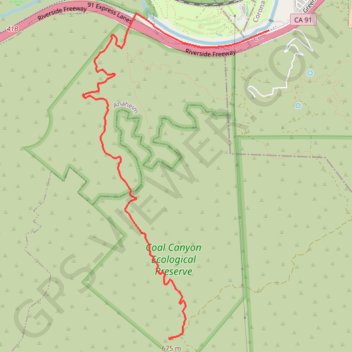
- Distance: 4.9 mi
- Elevation gain: 1,834 ft
- Maximum elevation: 2,218 ft
- Elevation loss: 79 ft
- Minimum elevation: 417 ft
Interactive trail map
Trail profile
- Distance: 4.9 mi
- Elevation gain: 1,834 ft
- Maximum elevation: 2,218 ft
- Elevation loss: 79 ft
- Minimum elevation: 417 ft
About this trail
Name: Coal Canyon trail, distance, elevation, map, profile, GPS track
End: Picnic Rock, Windy Ridge Trail, Orange County, California, United States (33.83824 -117.68217)
Coordinates: 33.83820 -117.69318 33.87295 -117.66926
Topography: Corona topographic map, elevation, terrain