Import a GPX file

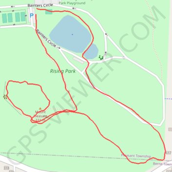
Mount Pleasant (Rising Park)

Loop hike to Mount Pleasant in Rising Park. #Hiking #Loop #Park #Forest #Nature

  • Distance: 1.1 mi
  • Elevation gain: 249 ft
  • Maximum elevation: 1,043 ft
  • Elevation loss: 249 ft
  • Minimum elevation: 879 ft
  • Moving time: 18 m 10 s
  • Moving speed: 3.8 mph
  • Maximum speed: 10.1 mph
  • Total time: 19 m 52 s
  • Global speed: 3.5 mph

Interactive trail map

Trail profile

  • Distance: 1.1 mi
  • Elevation gain: 249 ft
  • Maximum elevation: 1,043 ft
  • Elevation loss: 249 ft
  • Minimum elevation: 879 ft
  • Moving time: 18 m 10 s
  • Moving speed: 3.8 mph
  • Maximum speed: 10.1 mph
  • Total time: 19 m 52 s
  • Global speed: 3.5 mph

About this trail

Gear up for your next adventure:

💧Water Purification System - Clean water on the trail with reliable purifiers
🛡️Insect Repellent - Protection against bugs during outdoor activities
🌡️Handheld Weather Meters - Measure wind, temp, and pressure for safe mountain travel
🛌Ultralight Sleeping Bags - Compact down bags for cold nights in the wilderness
🧭Compass with Lanyard - Easy‑carry compass for navigation

As an Amazon Associate, this site earns from qualifying purchases at no extra cost to you.