Make a donation
Gear up for your next adventure:
As an Amazon Associate, this site earns from qualifying purchases at no extra cost to you.
Auburn State Recreation Area
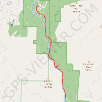
Hike from Iowa Hill Road to Yankee Jims Bridge along the North Fork American River via Windy Point Trail and Indian Creek Trail in the Auburn State Recreation Area. #Hiking #Nature #Mountain #River #Forest
- Distance: 5.4 mi
- Elevation gain: 1,263 ft
- Maximum elevation: 1,673 ft
- Elevation loss: 1,896 ft
- Minimum elevation: 925 ft
- Moving time: 3 h 35 m
- Moving speed: 1.5 mph
- Maximum speed: 3.8 mph
- Total time: 5 h 49 m
- Global speed: 0.9 mph
Interactive trail map
Make a donation
Gear up for your next adventure:
As an Amazon Associate, this site earns from qualifying purchases at no extra cost to you.
Trail profile
- Distance: 5.4 mi
- Elevation gain: 1,263 ft
- Maximum elevation: 1,673 ft
- Elevation loss: 1,896 ft
- Minimum elevation: 925 ft
- Moving time: 3 h 35 m
- Moving speed: 1.5 mph
- Maximum speed: 3.8 mph
- Total time: 5 h 49 m
- Global speed: 0.9 mph
Make a donation
Gear up for your next adventure:
As an Amazon Associate, this site earns from qualifying purchases at no extra cost to you.
About this trail
Name: Auburn State Recreation Area trail, distance, elevation, map, profile, GPS track
Start: Windy Point Trail, Placer County, California, 95713, United States (39.09081 -120.92120)
End: Yankee Jims Road, Placer County, California, United States (39.04027 -120.90217)
Coordinates: 39.04025 -120.92224 39.09081 -120.90193
Topography: Placer County topographic map, elevation, terrain
Make a donation
Gear up for your next adventure:
As an Amazon Associate, this site earns from qualifying purchases at no extra cost to you.