Thank you for supporting this site ❤️
Make a donation
Make a donation
Gear up for your next adventure:
As an Amazon Associate, this site earns from qualifying purchases at no extra cost to you.
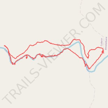
Walk
- Distance: 3.9 mi
- Elevation gain: 502 ft
- Maximum elevation: 2,356 ft
- Elevation loss: 499 ft
- Minimum elevation: 2,182 ft
Interactive trail map
Thank you for supporting this site ❤️
Make a donation
Make a donation
Gear up for your next adventure:
As an Amazon Associate, this site earns from qualifying purchases at no extra cost to you.
Trail profile
- Distance: 3.9 mi
- Elevation gain: 502 ft
- Maximum elevation: 2,356 ft
- Elevation loss: 499 ft
- Minimum elevation: 2,182 ft
Thank you for supporting this site ❤️
Make a donation
Make a donation
Gear up for your next adventure:
As an Amazon Associate, this site earns from qualifying purchases at no extra cost to you.
About this trail
Name: Walk trail, distance, elevation, map, profile, GPS track
Start: Cullerin, Upper Lachlan Shire Council, New South Wales, 2581, Australia (-34.75673 149.40438)
End: Cullerin, Upper Lachlan Shire Council, New South Wales, 2581, Australia (-34.75663 149.40439)
Coordinates: -34.75840 149.38809 -34.75364 149.40748
Thank you for supporting this site ❤️
Make a donation
Make a donation
Gear up for your next adventure:
As an Amazon Associate, this site earns from qualifying purchases at no extra cost to you.
Other hiking, mountain biking, running and outdoor activity trails
Click on a trail to view its statistics, map and profile.