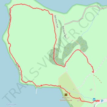
Bell Point Loop Trail in San Juan Island National Historical Park
- Distance: 1.6 mi
- Elevation gain: 226 ft
- Maximum elevation: 108 ft
- Elevation loss: 210 ft
- Minimum elevation: -3 ft
- Moving time: 47 m 46 s
- Moving speed: 2.0 mph
- Maximum speed: 11.7 mph
- Total time: 1 h 2 m
- Global speed: 1.5 mph
Interactive trail map
Trail profile
- Distance: 1.6 mi
- Elevation gain: 226 ft
- Maximum elevation: 108 ft
- Elevation loss: 210 ft
- Minimum elevation: -3 ft
- Moving time: 47 m 46 s
- Moving speed: 2.0 mph
- Maximum speed: 11.7 mph
- Total time: 1 h 2 m
- Global speed: 1.5 mph
About this trail
Name: Bell Point Loop Trail in San Juan Island National Historical Park trail, distance, elevation, map, profile, GPS track
Start: English Camp Main, San Juan County, Washington, United States (48.58826 -123.14817)
End: English Camp Main, San Juan County, Washington, United States (48.58630 -123.14793)
Coordinates: 48.58619 -123.15686 48.59282 -123.14756
Topography: San Juan County topographic map, elevation, terrain