Make a donation
Gear up for your next adventure:
As an Amazon Associate, this site earns from qualifying purchases at no extra cost to you.
2026-04-09--22-46-47
- Distance: 0.5 mi
- Elevation gain: 3 ft
- Maximum elevation: 184 ft
- Elevation loss: 138 ft
- Minimum elevation: 43 ft
- Moving time: 1 m 36 s
- Moving speed: 20.6 mph
- Maximum speed: 38.3 mph
- Total time: 9 m 27 s
- Global speed: 3.5 mph
Interactive trail map
Make a donation
Gear up for your next adventure:
As an Amazon Associate, this site earns from qualifying purchases at no extra cost to you.
Trail profile
- Distance: 0.5 mi
- Elevation gain: 3 ft
- Maximum elevation: 184 ft
- Elevation loss: 138 ft
- Minimum elevation: 43 ft
- Moving time: 1 m 36 s
- Moving speed: 20.6 mph
- Maximum speed: 38.3 mph
- Total time: 9 m 27 s
- Global speed: 3.5 mph
Make a donation
Gear up for your next adventure:
As an Amazon Associate, this site earns from qualifying purchases at no extra cost to you.
About this trail
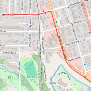
Name: 2026-04-09--22-46-47 trail, distance, elevation, map, profile, GPS track
Coordinates: 49.17301 -123.95184 49.17715 -123.94404
Make a donation
Gear up for your next adventure:
As an Amazon Associate, this site earns from qualifying purchases at no extra cost to you.
Other hiking, mountain biking, running and outdoor activity trails
Click on a trail to view its statistics, map and profile.
2026-04-10--08-57-53
Canada > British Columbia > Regional District of Nanaimo > Nanaimo
Distance: 43.9 mi • Elevation gain: 2,326 ft • Maximum elevation: 374 ft
2026-04-09--21-06-57
Canada > British Columbia > Regional District of Nanaimo > Nanaimo
Distance: 5.0 mi • Elevation gain: 75 ft • Maximum elevation: 397 ft
2026-04-10--01-15-41
Canada > British Columbia > Regional District of Nanaimo > Nanaimo
Distance: 4.0 mi • Elevation gain: 358 ft • Maximum elevation: 184 ft