Make a donation
Gear up for your next adventure:
As an Amazon Associate, this site earns from qualifying purchases at no extra cost to you.
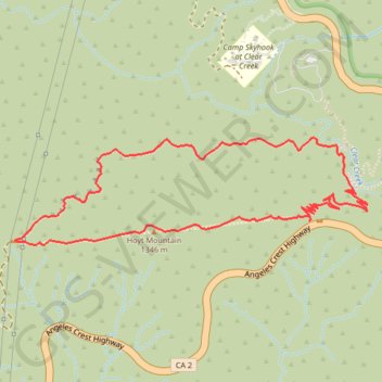
Hoyt Mountain Loop
Loop hike from Georges Gap to Hoyt Mountain via Clear Creek Vista, Firebreak, Tank Saddle, Telephone Trail and World of Chaparral Trail in the Angeles National Forest. #Hiking #Loop #Mountain #Nature #Forest #Angeles
- Distance: 3.5 mi
- Elevation gain: 1,594 ft
- Maximum elevation: 4,377 ft
- Elevation loss: 1,594 ft
- Minimum elevation: 3,163 ft
Interactive trail map
Make a donation
Gear up for your next adventure:
As an Amazon Associate, this site earns from qualifying purchases at no extra cost to you.
Trail profile
- Distance: 3.5 mi
- Elevation gain: 1,594 ft
- Maximum elevation: 4,377 ft
- Elevation loss: 1,594 ft
- Minimum elevation: 3,163 ft
Make a donation
Gear up for your next adventure:
As an Amazon Associate, this site earns from qualifying purchases at no extra cost to you.
About this trail
Name: Hoyt Mountain Loop trail, distance, elevation, map, profile, GPS track
Start: World Of Chaparral Trail, Los Angeles County, California, United States (34.26975 -118.16840)
End: World Of Chaparral Trail, Los Angeles County, California, United States (34.26974 -118.16841)
Coordinates: 34.26868 -118.18459 34.27356 -118.16518
Topography: Los Angeles County topographic map, elevation, terrain
Make a donation
Gear up for your next adventure:
As an Amazon Associate, this site earns from qualifying purchases at no extra cost to you.