Make a donation
Gear up for your next adventure:
As an Amazon Associate, this site earns from qualifying purchases at no extra cost to you.
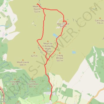
Tracked with OSMTracker for Android™
- Distance: 7.7 mi
- Elevation gain: 2,654 ft
- Maximum elevation: 2,733 ft
- Elevation loss: 2,661 ft
- Minimum elevation: 587 ft
- Moving time: 3 h 48 m
- Moving speed: 2.0 mph
- Maximum speed: 5.8 mph
- Total time: 4 h 45 m
- Global speed: 1.6 mph
Interactive trail map
Make a donation
Gear up for your next adventure:
As an Amazon Associate, this site earns from qualifying purchases at no extra cost to you.
Trail profile
- Distance: 7.7 mi
- Elevation gain: 2,654 ft
- Maximum elevation: 2,733 ft
- Elevation loss: 2,661 ft
- Minimum elevation: 587 ft
- Moving time: 3 h 48 m
- Moving speed: 2.0 mph
- Maximum speed: 5.8 mph
- Total time: 4 h 45 m
- Global speed: 1.6 mph
Make a donation
Gear up for your next adventure:
As an Amazon Associate, this site earns from qualifying purchases at no extra cost to you.
About this trail
Name: Tracked with OSMTracker for Android™ trail, distance, elevation, map, profile, GPS track
Coordinates: 56.71542 -3.73777 56.75649 -3.71450
Make a donation
Gear up for your next adventure:
As an Amazon Associate, this site earns from qualifying purchases at no extra cost to you.
Other hiking, mountain biking, running and outdoor activity trails
Click on a trail to view its statistics, map and profile.
EMTB Gravel: Loch a' Choire loop
United Kingdom > Scotland > Perth and Kinross > Moulin > Balnakeilly
To Loch a' Choire beneath Ben Vrackie #UK #Perthshire #Pitlochry
Distance: 4.1 mi • Elevation gain: 1,017 ft • Maximum elevation: 1,752 ft
EMTB Gravel: Pitlochry Highlights - Loop
United Kingdom > Scotland > Perth and Kinross > Pitlochry
Distance: 10.1 mi • Elevation gain: 1,834 ft • Maximum elevation: 1,473 ft
Loch Tummel Loop
United Kingdom > Scotland > Perth and Kinross > Pitlochry
To Escape Route Cafe UK, Perthshire, Loch Tummel
Distance: 28.7 mi • Elevation gain: 2,687 ft • Maximum elevation: 948 ft