Make a donation
Gear up for your next adventure:
As an Amazon Associate, this site earns from qualifying purchases at no extra cost to you.
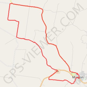
Murgon to Byee and back via Merlwood
- Distance: 25.3 mi
- Elevation gain: 1,155 ft
- Maximum elevation: 1,155 ft
- Elevation loss: 1,155 ft
- Minimum elevation: 892 ft
Interactive trail map
Make a donation
Gear up for your next adventure:
As an Amazon Associate, this site earns from qualifying purchases at no extra cost to you.
Trail profile
- Distance: 25.3 mi
- Elevation gain: 1,155 ft
- Maximum elevation: 1,155 ft
- Elevation loss: 1,155 ft
- Minimum elevation: 892 ft
Make a donation
Gear up for your next adventure:
As an Amazon Associate, this site earns from qualifying purchases at no extra cost to you.
About this trail
Name: Murgon to Byee and back via Merlwood trail, distance, elevation, map, profile, GPS track
Coordinates: -26.24952 151.83786 -26.14375 151.94253
Make a donation
Gear up for your next adventure:
As an Amazon Associate, this site earns from qualifying purchases at no extra cost to you.
Other hiking, mountain biking, running and outdoor activity trails
Click on a trail to view its statistics, map and profile.
Murgon - Kingaroy
Australia > Queensland > Murgon
#Bike
Distance: 30.1 mi • Elevation gain: 1,099 ft • Maximum elevation: 1,604 ft
Ficks Crossing to Mount McEuen Queensland
Australia > Queensland > Ficks Crossing
Ficks Crossing, Wheatlands, Vhelmsford, Leafdale, Keysland, Mt McEuen, Fairdale, Queensland
Distance: 28.8 mi • Elevation gain: 1,316 ft • Maximum elevation: 1,368 ft
Murgon to Cloyna via Boat Mountain
Australia > Queensland > Murgon
Murgon, Tablelends, Merlwood, Warnung, Cloyna, Byee, Barlil, Queensland
Distance: 32.9 mi • Elevation gain: 2,136 ft • Maximum elevation: 1,680 ft
Ficks Crossing to Hivesville
Australia > Queensland > Wheatlands
Ficks Crossing, Wheatlands, Silverleaf, Marshlands, Hivesville, Leafdale, Keysland, Chelmsford, Queensland
Distance: 34.0 mi • Elevation gain: 1,296 ft • Maximum elevation: 1,421 ft
Make a donation
Gear up for your next adventure:
As an Amazon Associate, this site earns from qualifying purchases at no extra cost to you.
Byee to Greenview, Cushnie and Mondure
Australia > Queensland > Byee
Distance: 34.3 mi • Elevation gain: 1,250 ft • Maximum elevation: 1,539 ft
Wheatlands to Wooroonden
Australia > Queensland > Wheatlands
Wheatlands, Byee, Silverleaf, Wooroonden, Marshlands, Mondure, Queensland
Distance: 26.5 mi • Elevation gain: 591 ft • Maximum elevation: 1,010 ft
Murgon, Ficks Crossing and Greenview
Australia > Queensland > Wondai
Distance: 25.0 mi • Elevation gain: 1,260 ft • Maximum elevation: 1,198 ft
Mondure to Windera Park
Mondure, Silverleaf, Warnung, Cloyna, Kitoba, Windera, Glenrock
Distance: 34.6 mi • Elevation gain: 1,063 ft • Maximum elevation: 1,007 ft
Make a donation
Gear up for your next adventure:
As an Amazon Associate, this site earns from qualifying purchases at no extra cost to you.
Murgon and Wondai streets
Australia > Queensland > Murgon
Distance: 24.1 mi • Elevation gain: 1,112 ft • Maximum elevation: 1,145 ft
Tinny-Murgon
Australia > Queensland > Tingoora
Rail trail and roads Tingoora to Murgon
Distance: 31.5 mi • Elevation gain: 1,352 ft • Maximum elevation: 1,358 ft
Byee Wheatlands
Byee, Wheatlands, Ficks Crossing, Queensland
Distance: 15.2 mi • Elevation gain: 331 ft • Maximum elevation: 1,132 ft