Attunga trails
Attunga trail mapping
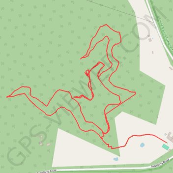
- Distance: 3.7 mi
- Elevation gain: 1,050 ft
- Maximum elevation: 2,392 ft
- Elevation loss: 1,135 ft
- Minimum elevation: 2,047 ft
- Moving time: 51 m 39 s
- Moving speed: 4.3 mph
- Maximum speed: 14.7 mph
- Total time: 51 m 39 s
- Global speed: 4.3 mph
Interactive trail map
Trail profile
- Distance: 3.7 mi
- Elevation gain: 1,050 ft
- Maximum elevation: 2,392 ft
- Elevation loss: 1,135 ft
- Minimum elevation: 2,047 ft
- Moving time: 51 m 39 s
- Moving speed: 4.3 mph
- Maximum speed: 14.7 mph
- Total time: 51 m 39 s
- Global speed: 4.3 mph
About this trail
Name: Attunga trails trail, distance, elevation, map, profile, GPS track
Coordinates: -34.41830 150.14265 -34.41121 150.15375