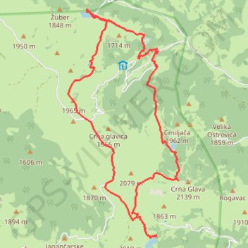
Bjelasica lakes trail
- Distance: 10.1 mi
- Elevation gain: 2,963 ft
- Maximum elevation: 6,834 ft
- Elevation loss: 3,005 ft
- Minimum elevation: 5,059 ft
Interactive trail map
Trail profile
- Distance: 10.1 mi
- Elevation gain: 2,963 ft
- Maximum elevation: 6,834 ft
- Elevation loss: 3,005 ft
- Minimum elevation: 5,059 ft
About this trail
Name: Bjelasica lakes trail trail, distance, elevation, map, profile, GPS track
Start: HT 301, Katun Šiška, Berane Municipality, Montenegro (42.89864 19.67241)
End: HT 301, Katun Šiška, Berane Municipality, Montenegro (42.89832 19.67242)
Coordinates: 42.85597 19.66757 42.89887 19.69588
Other hiking, mountain biking, running and outdoor activity trails
Click on a trail to view its statistics, map and profile.
2022_Yu
Slovenia > Ajdovščina > Žapuže
Distance: 1,526.9 mi • Elevation gain: 105,144 ft • Maximum elevation: 6,398 ft