Thank you for supporting this site ❤️
Make a donation
Make a donation
Gear up for your next adventure:
As an Amazon Associate, this site earns from qualifying purchases at no extra cost to you.
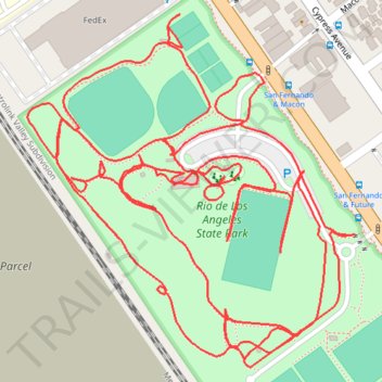
Rio de Los Angeles State Park
- Distance: 2.9 mi
- Elevation gain: 49 ft
- Maximum elevation: 381 ft
- Elevation loss: 49 ft
- Minimum elevation: 354 ft
- Moving time: 38 m 50 s
- Moving speed: 4.5 mph
- Maximum speed: 8.2 mph
- Total time: 38 m 50 s
- Global speed: 4.5 mph
Interactive trail map
Thank you for supporting this site ❤️
Make a donation
Make a donation
Gear up for your next adventure:
As an Amazon Associate, this site earns from qualifying purchases at no extra cost to you.
Trail profile
- Distance: 2.9 mi
- Elevation gain: 49 ft
- Maximum elevation: 381 ft
- Elevation loss: 49 ft
- Minimum elevation: 354 ft
- Moving time: 38 m 50 s
- Moving speed: 4.5 mph
- Maximum speed: 8.2 mph
- Total time: 38 m 50 s
- Global speed: 4.5 mph
Thank you for supporting this site ❤️
Make a donation
Make a donation
Gear up for your next adventure:
As an Amazon Associate, this site earns from qualifying purchases at no extra cost to you.
About this trail
Name: Rio de Los Angeles State Park trail, distance, elevation, map, profile, GPS track
Coordinates: 34.09684 -118.23890 34.10093 -118.23432
Topography: Los Angeles topographic map, elevation, terrain
Thank you for supporting this site ❤️
Make a donation
Make a donation
Gear up for your next adventure:
As an Amazon Associate, this site earns from qualifying purchases at no extra cost to you.