Make a donation
Gear up for your next adventure:
As an Amazon Associate, this site earns from qualifying purchases at no extra cost to you.
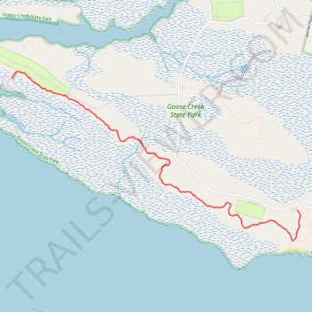
Goose Creek Trail
- Distance: 2.4 mi
- Elevation gain: 49 ft
- Maximum elevation: 23 ft
- Elevation loss: 46 ft
- Minimum elevation: 3 ft
- Moving time: 46 m 33 s
- Moving speed: 3.1 mph
- Maximum speed: 4.1 mph
- Total time: 46 m 33 s
- Global speed: 3.1 mph
Interactive trail map
Make a donation
Gear up for your next adventure:
As an Amazon Associate, this site earns from qualifying purchases at no extra cost to you.
Trail profile
- Distance: 2.4 mi
- Elevation gain: 49 ft
- Maximum elevation: 23 ft
- Elevation loss: 46 ft
- Minimum elevation: 3 ft
- Moving time: 46 m 33 s
- Moving speed: 3.1 mph
- Maximum speed: 4.1 mph
- Total time: 46 m 33 s
- Global speed: 3.1 mph
Make a donation
Gear up for your next adventure:
As an Amazon Associate, this site earns from qualifying purchases at no extra cost to you.
About this trail
Name: Goose Creek Trail trail, distance, elevation, map, profile, GPS track
End: Goose Creek Trail, Beaufort County, North Carolina, United States (35.46379 -76.90009)
Coordinates: 35.46144 -76.92714 35.47449 -76.89981
Topography: Beaufort County topographic map, elevation, terrain
Make a donation
Gear up for your next adventure:
As an Amazon Associate, this site earns from qualifying purchases at no extra cost to you.
Other hiking, mountain biking, running and outdoor activity trails
Click on a trail to view its statistics, map and profile.
Goose Creek State Park
United States > North Carolina > Beaufort County
Afternoon hike
Distance: 5.2 mi • Elevation gain: 92 ft • Maximum elevation: 23 ft
Goose Creek and Flatty Creek Trail
United States > North Carolina > Beaufort County
Distance: 2.8 mi • Elevation gain: 56 ft • Maximum elevation: 23 ft