Make a donation
Gear up for your next adventure:
As an Amazon Associate, this site earns from qualifying purchases at no extra cost to you.
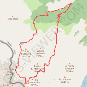
Pic du Montcalm - Étang d'Estats - Étang du Pinet - Étang Sourd
- Distance: 11.7 mi
- Elevation gain: 6,624 ft
- Maximum elevation: 10,056 ft
- Elevation loss: 6,621 ft
- Minimum elevation: 3,681 ft
Interactive trail map
Make a donation
Gear up for your next adventure:
As an Amazon Associate, this site earns from qualifying purchases at no extra cost to you.
Trail profile
- Distance: 11.7 mi
- Elevation gain: 6,624 ft
- Maximum elevation: 10,056 ft
- Elevation loss: 6,621 ft
- Minimum elevation: 3,681 ft
Make a donation
Gear up for your next adventure:
As an Amazon Associate, this site earns from qualifying purchases at no extra cost to you.
About this trail
Name: Pic du Montcalm - Étang d'Estats - Étang du Pinet - Étang Sourd trail, distance, elevation, map, profile, GPS track
Start: D 66, Tuto, Auzat, Foix, Ariège, Occitania, Metropolitan France, 09220, France (42.71387 1.43499)
End: D 66, Tuto, Auzat, Foix, Ariège, Occitania, Metropolitan France, 09220, France (42.71386 1.43501)
Coordinates: 42.66827 1.39152 42.71387 1.43501
Make a donation
Gear up for your next adventure:
As an Amazon Associate, this site earns from qualifying purchases at no extra cost to you.
Other hiking, mountain biking, running and outdoor activity trails
Click on a trail to view its statistics, map and profile.
GR 10 - Traversée des Pyrénées
France > Occitania > Pyrénées-Orientales > Banyuls-sur-Mer
Distance: 543.6 mi • Elevation gain: 187,008 ft • Maximum elevation: 8,527 ft
Southern section — European Divide Trail
France > Auvergne-Rhône-Alpes > Drôme > Valence
Distance: 1,506.1 mi • Elevation gain: 139,026 ft • Maximum elevation: 6,578 ft
1 LUCENA - MONTPELLIER
Distance: 1,842.0 mi • Elevation gain: 96,785 ft • Maximum elevation: 3,438 ft