Make a donation
Gear up for your next adventure:
As an Amazon Associate, this site earns from qualifying purchases at no extra cost to you.
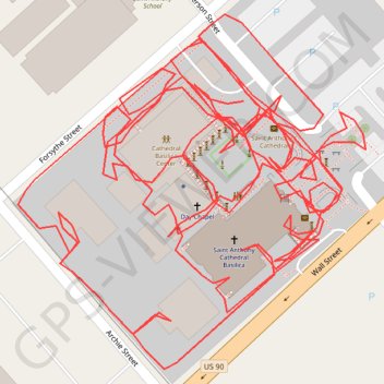
Saint Anthony Cathedral Basilic Footways
- Distance: 1.3 mi
- Elevation gain: 20 ft
- Maximum elevation: 30 ft
- Elevation loss: 20 ft
- Minimum elevation: 20 ft
- Moving time: 31 m 30 s
- Moving speed: 2.4 mph
- Maximum speed: 3.6 mph
- Total time: 32 m
- Global speed: 2.4 mph
Interactive trail map
Make a donation
Gear up for your next adventure:
As an Amazon Associate, this site earns from qualifying purchases at no extra cost to you.
Trail profile
- Distance: 1.3 mi
- Elevation gain: 20 ft
- Maximum elevation: 30 ft
- Elevation loss: 20 ft
- Minimum elevation: 20 ft
- Moving time: 31 m 30 s
- Moving speed: 2.4 mph
- Maximum speed: 3.6 mph
- Total time: 32 m
- Global speed: 2.4 mph
Make a donation
Gear up for your next adventure:
As an Amazon Associate, this site earns from qualifying purchases at no extra cost to you.
About this trail
Name: Saint Anthony Cathedral Basilic Footways trail, distance, elevation, map, profile, GPS track
Start: 728, Jefferson Street, Beaumont, Jefferson County, Texas, 77701, United States (30.07818 -94.10090)
End: 740, Jefferson Street, Beaumont, Jefferson County, Texas, 77701, United States (30.07814 -94.10080)
Coordinates: 30.07719 -94.10186 30.07850 -94.10038
Topography: Beaumont topographic map, elevation, terrain
Make a donation
Gear up for your next adventure:
As an Amazon Associate, this site earns from qualifying purchases at no extra cost to you.