Make a donation
Gear up for your next adventure:
As an Amazon Associate, this site earns from qualifying purchases at no extra cost to you.
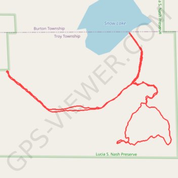
Lucia Nash Preserve, Burton, OH
- Distance: 2.4 mi
- Elevation gain: 95 ft
- Maximum elevation: 1,125 ft
- Elevation loss: 95 ft
- Minimum elevation: 1,079 ft
- Moving time: 1 h 12 m
- Moving speed: 2.0 mph
- Maximum speed: 6.8 mph
- Total time: 2 h 8 m
- Global speed: 1.1 mph
Interactive trail map
Make a donation
Gear up for your next adventure:
As an Amazon Associate, this site earns from qualifying purchases at no extra cost to you.
Trail profile
- Distance: 2.4 mi
- Elevation gain: 95 ft
- Maximum elevation: 1,125 ft
- Elevation loss: 95 ft
- Minimum elevation: 1,079 ft
- Moving time: 1 h 12 m
- Moving speed: 2.0 mph
- Maximum speed: 6.8 mph
- Total time: 2 h 8 m
- Global speed: 1.1 mph
Make a donation
Gear up for your next adventure:
As an Amazon Associate, this site earns from qualifying purchases at no extra cost to you.
About this trail
Name: Lucia Nash Preserve, Burton, OH trail, distance, elevation, map, profile, GPS track
Start: Snow Lake Trail, Troy Township, Geauga County, Ohio, 44021, United States (41.42407 -81.18131)
End: Snow Lake Trail, Troy Township, Geauga County, Ohio, 44021, United States (41.42408 -81.18132)
Coordinates: 41.42106 -81.18141 41.42568 -81.17236
Topography: Geauga County topographic map, elevation, terrain
Make a donation
Gear up for your next adventure:
As an Amazon Associate, this site earns from qualifying purchases at no extra cost to you.