Thank you for supporting this site ❤️
Make a donation
Make a donation
Gear up for your next adventure:
As an Amazon Associate, this site earns from qualifying purchases at no extra cost to you.
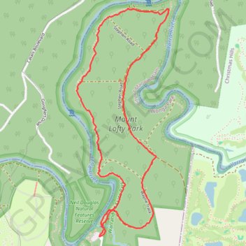
Mount Lofty Loop
Yarra River. Warrandyte State Park. #Hiking #Loop #Warrandyte
- Distance: 3.1 mi
- Elevation gain: 427 ft
- Maximum elevation: 397 ft
- Elevation loss: 427 ft
- Minimum elevation: 167 ft
- Moving time: 55 m 13 s
- Moving speed: 3.4 mph
- Maximum speed: 6.6 mph
- Total time: 55 m 13 s
- Global speed: 3.4 mph
Interactive trail map
Thank you for supporting this site ❤️
Make a donation
Make a donation
Gear up for your next adventure:
As an Amazon Associate, this site earns from qualifying purchases at no extra cost to you.
Trail profile
- Distance: 3.1 mi
- Elevation gain: 427 ft
- Maximum elevation: 397 ft
- Elevation loss: 427 ft
- Minimum elevation: 167 ft
- Moving time: 55 m 13 s
- Moving speed: 3.4 mph
- Maximum speed: 6.6 mph
- Total time: 55 m 13 s
- Global speed: 3.4 mph
Thank you for supporting this site ❤️
Make a donation
Make a donation
Gear up for your next adventure:
As an Amazon Associate, this site earns from qualifying purchases at no extra cost to you.
About this trail
Name: Mount Lofty Loop trail, distance, elevation, map, profile, GPS track
Coordinates: -37.71832 145.28392 -37.70337 145.29157
Thank you for supporting this site ❤️
Make a donation
Make a donation
Gear up for your next adventure:
As an Amazon Associate, this site earns from qualifying purchases at no extra cost to you.
Other hiking, mountain biking, running and outdoor activity trails
Click on a trail to view its statistics, map and profile.
Tallarook - Eildon - Hurstbridge
Australia > Victoria > Tallarook
#Bike
Distance: 173.2 mi • Elevation gain: 16,066 ft • Maximum elevation: 2,848 ft