Thank you for supporting this site ❤️
Make a donation
Make a donation
Gear up for your next adventure:
As an Amazon Associate, this site earns from qualifying purchases at no extra cost to you.
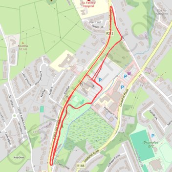
Con Smith Park run
- Distance: 3.1 mi
- Elevation gain: 128 ft
- Maximum elevation: 262 ft
- Elevation loss: 128 ft
- Minimum elevation: 210 ft
- Moving time: 21 m
- Moving speed: 8.9 mph
- Maximum speed: 12.7 mph
- Total time: 21 m
- Global speed: 8.9 mph
Interactive trail map
Thank you for supporting this site ❤️
Make a donation
Make a donation
Gear up for your next adventure:
As an Amazon Associate, this site earns from qualifying purchases at no extra cost to you.
Trail profile
- Distance: 3.1 mi
- Elevation gain: 128 ft
- Maximum elevation: 262 ft
- Elevation loss: 128 ft
- Minimum elevation: 210 ft
- Moving time: 21 m
- Moving speed: 8.9 mph
- Maximum speed: 12.7 mph
- Total time: 21 m
- Global speed: 8.9 mph
Thank you for supporting this site ❤️
Make a donation
Make a donation
Gear up for your next adventure:
As an Amazon Associate, this site earns from qualifying purchases at no extra cost to you.
About this trail
Name: Con Smith Park run trail, distance, elevation, map, profile, GPS track
Coordinates: 53.99703 -7.36034 54.00425 -7.35477
Thank you for supporting this site ❤️
Make a donation
Make a donation
Gear up for your next adventure:
As an Amazon Associate, this site earns from qualifying purchases at no extra cost to you.
Other hiking, mountain biking, running and outdoor activity trails
Click on a trail to view its statistics, map and profile.
Con Smith Park
Ireland > County Cavan > Cavan
Morning Run
Distance: 1.8 mi • Elevation gain: 39 ft • Maximum elevation: 226 ft