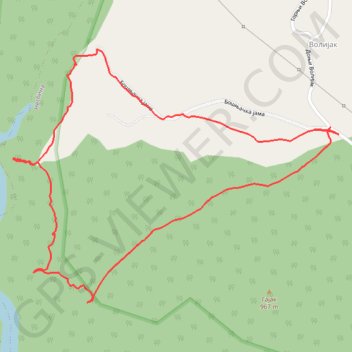
Uvac (Zlatiborska strana)
- Distance: 1.9 mi
- Elevation gain: 512 ft
- Maximum elevation: 3,136 ft
- Elevation loss: 512 ft
- Minimum elevation: 2,756 ft
- Moving time: 1 h 33 s
- Moving speed: 1.9 mph
- Maximum speed: 3.8 mph
- Total time: 1 h 45 m
- Global speed: 1.1 mph
Interactive trail map
Trail profile
- Distance: 1.9 mi
- Elevation gain: 512 ft
- Maximum elevation: 3,136 ft
- Elevation loss: 512 ft
- Minimum elevation: 2,756 ft
- Moving time: 1 h 33 s
- Moving speed: 1.9 mph
- Maximum speed: 3.8 mph
- Total time: 1 h 45 m
- Global speed: 1.1 mph
About this trail
Name: Uvac (Zlatiborska strana) trail, distance, elevation, map, profile, GPS track
Coordinates: 43.52474 19.77991 43.53108 19.79112
Other hiking, mountain biking, running and outdoor activity trails
Click on a trail to view its statistics, map and profile.
2022_Yu
Slovenia > Ajdovščina > Žapuže
Distance: 1,526.9 mi • Elevation gain: 105,144 ft • Maximum elevation: 6,398 ft